4. Soil and post-glacial rebound
Contents
4.1 Types of soil
The continental glaciers of the last Ice Age transported away almost all of the loose soil that had previously been on top of the Finnish bedrock. This is why the Finnish soil is very thin, being only about 3-4 meters deep on avereage.
On the other hand, the Finnish soil covers the bedrock almost completely. Only a small percentage of the nation's surface area consists of bare rock.
Like types of rock, types of soil can also be divided into two groups depending on how they have formed. The two groups are mineral soil types and organic soil types.

Mineral soil types consist of small pieces of rock. Gravel, sand and clay are all mineral soil types.
Mineral soil types have formed when rock has weathered and been ground into smaller particles. In areas affected by the ice ages, this has often occurred as a result of glacial movement. Mineral soil types can be divided into different groups depending on their particle size, with gravel being the most coarse and clay being the finest.
Sand and gravel can be found in great amounts in eskers and terminal moraine ridges, whereas clay is a type of mineral soil more typical to lowland areas, such as Southern Finland and Ostrobothnia. The most common Finnish soil type is till, which has formed as the result of glacial movements that have ground and mixed different materials together. Till is a mixture of sand and clay. Fine till can be used for agriculture, whereas coarser till often accommodates forest growth.
Organic soil types have formed when organic matter, such as plant parts and animal remains, has decomposed and compressed into layers. Organic soil types often contain small amounts of mineral soil types, as well. Most of the Finnish organic soil types have formed only after the last Ice Age. The most common soil type in Finnish coniferous forests is thick mor. Organic soil types, such as clay soil, are rich in nutrients and therefore useful for agricultural use. Finnish agricultural soil is usally a mixture of clay and organic matter. Bogs consist of wet peat, whereas the bottoms of Finnish bodies of water often consist of silt or mud.

Organic soil types are rich in nutrient, which makes them useful for agriculture.
On the other hand, the Finnish soil covers the bedrock almost completely. Only a small percentage of the nation's surface area consists of bare rock.
Like types of rock, types of soil can also be divided into two groups depending on how they have formed. The two groups are mineral soil types and organic soil types.

Mineral soil types consist of small pieces of rock. Gravel, sand and clay are all mineral soil types.
Mineral soil types have formed when rock has weathered and been ground into smaller particles. In areas affected by the ice ages, this has often occurred as a result of glacial movement. Mineral soil types can be divided into different groups depending on their particle size, with gravel being the most coarse and clay being the finest.
Sand and gravel can be found in great amounts in eskers and terminal moraine ridges, whereas clay is a type of mineral soil more typical to lowland areas, such as Southern Finland and Ostrobothnia. The most common Finnish soil type is till, which has formed as the result of glacial movements that have ground and mixed different materials together. Till is a mixture of sand and clay. Fine till can be used for agriculture, whereas coarser till often accommodates forest growth.
Organic soil types have formed when organic matter, such as plant parts and animal remains, has decomposed and compressed into layers. Organic soil types often contain small amounts of mineral soil types, as well. Most of the Finnish organic soil types have formed only after the last Ice Age. The most common soil type in Finnish coniferous forests is thick mor. Organic soil types, such as clay soil, are rich in nutrients and therefore useful for agricultural use. Finnish agricultural soil is usally a mixture of clay and organic matter. Bogs consist of wet peat, whereas the bottoms of Finnish bodies of water often consist of silt or mud.

Organic soil types are rich in nutrient, which makes them useful for agriculture.
4.2 Post-glacial rebound
 Finnish environments show many signs of being submerged by water once upon a time. In fact, many Finnish hills used to be islands and islets.
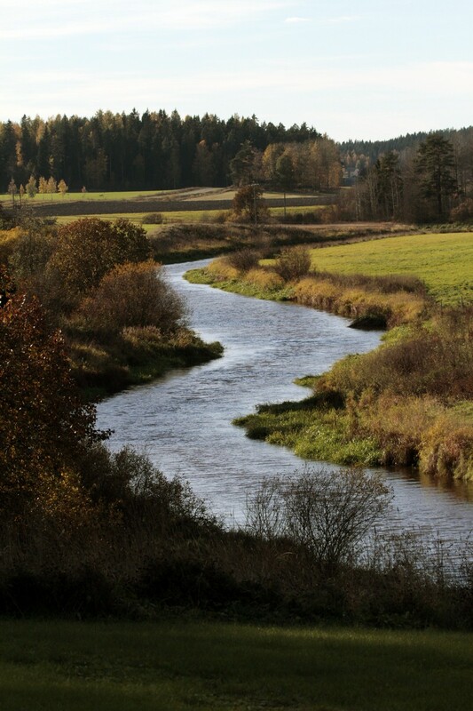
Fine soil has accumulated near the depressions between different hills and formed clay valleys. This process continues to this day. The picture on the right shows a river valley in Tavastia Proper, where clay has accumulated in a valley in the ancient seafloor.
Small islets are connected to each other, become islands and are finally connected with the continent. The largest island in the Bothnian Bay, Hailuoto, is a good example of this process.
Post-glacial rebound causes ground to rise in certain areas. This process makes the Finnish land surface area grow by seven square kilometers every ear. At the same time, the Bothnian Bay is slowly transforming into a lake. This will happen in two thousand years, when the ground of the Kvarken has risen above the sea level.
The shores of Ostrobothnia are slowly moving further towards the sea, transforming former coastal cities into inland cities. This has happened in Ulvila, for example, which was originally formed near the seashore but is now an inland town.
Post-glacial rebound has also resulted in many bodies of water being separated from the Baltic Sea. This has resulted in the formation of several Finnish lakes, such as Lake Saimaa. The animal species that have survived the change from saltwater into freshwater ecosystem, such as the Saimaa ringed seal, are examples of relic species.
Post-glacial rebound will cause Ostrobothnian rivers to flood more drastically in the future. Because the mouths of these rivers will rise, the flow speed of the rivers will also decrease. In addition, the Finnish landmass is slowly angling towards the southwest, which has caused changes in the flow directions of certain rivers. For example, the waters of the Lake Päijänne used to flow into the Gulf of Bothnia, but approximately 6 000 years ago they began to flow towards the south. Today, the waters of Lake Päijänne flow into the Gulf of Finland via the Kymijoki river.
Finnish inland areas have been covered by the sea or various freshwater bodies during the post-glacial period. This has resulted in the formation of ancient shores, where the waves have smoothed down rocks and piled up sandbanks near hills and ridges. Sometimes, these waves have carried away all the loose material except for the large rocks. This has caused the formation of rocky shingle beaches. As a result of post-glacial rebound, these beaches can today be found even at elevations of 200 meters!

A shingle beach in Nunnavuori, Turku.
4.3 Gallery: The effects of post-glacial rebound
4.4 Stages of the Baltic Sea
In geological terms, the Baltic Sea is a young sea. Its history has been researched by studying the fossils left by water-dwelling gastropods and clams. By studying their shells, the salt concentration and temperature of the seawater can be estimated. This gives us more information about the history of the Baltic Sea.
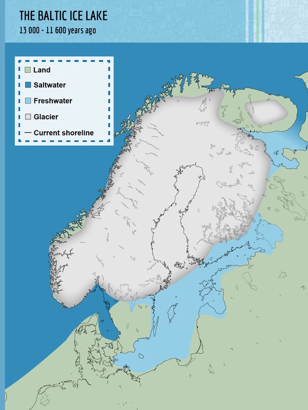
The history of the Baltic Sea consists of four distinct stages. Two of these stages are saltwater sea stages, whereas the other two are freshwater lake stages:
The history of the Baltic Sea consists of four distinct stages. Two of these stages are saltwater sea stages, whereas the other two are freshwater lake stages:
- The Baltic Ice Lake. 13 000 – 11 600 years ago. The water of the melting glacier formed a cold lake.
- The Yoldia Sea. 11 600 – 10 800 years ago. The sea was formed when a strait was formed near Central Sweden, connecting the Baltic Ice Lake with the North Sea. Southern Finland was covered by the sea. The seafloor accumulated a lot of clay and other materials.
- The Ancylus Lake. 10 800 – 9 000 years ago. Post-glacial rebound caused the strait to the North Sea to become disconnected. The water of the Baltic became fresh once again.
- The Litorina Sea. 9 000 – 3 000 years ago. The surfaces of the planet's oceans rose, creating another link with the North Sea via the straits of Denmark. When the land continued to rise due to post-glacial rebound, the connection with the North Sea became more narrow. The modern Baltic Sea became to form approximately 2 000 years ago.
 |
 |
 |
 |
4.5 What causes post-glacial rebound?
 During the last Ice Age, the majority of Fennoscandia was covered by a continental glacier that was almost three kilometers thick. The enormous weight of the glacier caused a lot of pressure to mount against the Earth's crust.
As a result of this pressure, the crust of the Earth sank deep into the planet's mantle, forming a hole that was almost a kilometer deep. Material from the top layer of the Earth's mantle moved towards the edges of this hole.
As the climate grew warmer, the continental glacier began to melt. This made the pressure it caused against the Earth's crust to decrease. In addition, materials that had moved to the edges of the pressurized area began to move towards the center of the hole. This resulted in post-glacial rebound.
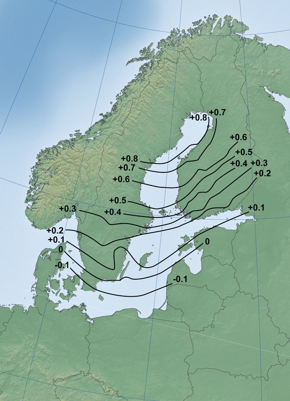
At first, post-glacial rebound was extremely fast. Over time, the process has slowed down. Today, the ground rises by only eight millimeters each year at the highest.
Post-glacial rebound occurs at the greatest rate near the Bothnian Bay, because the region was the last to be cleared of the continental ice mass when it retreated to the northwest. In Southern Finland, post-glacial rebound occurs at a rate of 2 millimeters per year, whereas in Southern Sweden no post-glacial rebound takes place.
During the millennia that have followed the last ice age, the ground has risen approximately 300 m. Post-glacial rebound is thought to continue, and the land is thought to rise for another 100–150 meters over the course of the next ten thousand years. This process is gradually slowing down as to the planet's crust returns to its original level.


