3. The Ice Age
Contents
3.1 We live in an ice age
For some, the term ice age might bring to mind only a series of animated movies where a squirrel desperately tries to crack a nut. However, everything that is not built by humans has been affected by the last ice age and the events that followed it.
In the Northern Hemisphere the ice age – or, to be precise, multiple ice ages – have molded the landscape and affected the people, plants and animals that lived there during that time. Even after the ice age, we still make use of the geographical features that have been created by it. For example, we cultivate plants in clay fields and filter groundwater from eskers.
Many ice age periods are known to have taken place during the planet's history. The latest of these ice ages began approximately 2,5 million years ago. Because ice ages destroy most of the signs left by the previous ice ages, it is difficult to study older ice ages. In Finland, we can still find signs from at least five different ice ages. However, the majority of the geographic features found in Finnish landscapes are specifically the result of the last ice age.

Glaciers can still be found in Iceland.
3.2 The rise and fall of the last ice age
An ice age occurs when the temperature of the planet falls over time. When this happens, glaciers near the planet's poles and mountain ranges begin to grow in size, since they do not melt fast enough during the summer. Ice ages are separated from each other by long, warm periods. However, shorter warm periods can also occur within ice ages.

The last Ice Age, or the period of Quarternary glaciation, began approximately 115 000 years ago and was at its peak approximately 25 000 years ago. The ice advancing from the Scandes was connected to the ice advancing from the Ural Mountains, leaving a continental glacier that was approximately three kilometers thick and covered all of Fennoscandia and Baltia, stretching as far as Northern Germany.
During this ice age, Finland was at times completely free of ice, despite the fact that the continental glaciers began to retreat from Southwestern Finland only approximately 13 000 years ago. There have been suggestions that even giant mammoths roamed the Finnish landscape during one of these iceless periods 30 000 – 40 000 years ago. Compared to the rate at which the continental glacier advanced across Northern Europe, its retreat from Northern Europe took place significantly faster. This meant that the whole of Finland was freed from the continental glacier for good over a period of 3 000 years.
What caused the planet's climate to grow colder? Earth's climate can change depending on various factors, and these changes can take place on different time spans. The changes in the planet's temperature that took place over hundreds and tens of millions of years were probably caused by plate tectonics, which resulted in the formation of mountain ranges and shifts in ocean currents. This changed the climatic conditions of polar regions significantly.
Ice ages are also thought to be partly the result of changes in the planet's route and angle of orbit. Although these changes do not always have drastic effects on the amount of heat radiation received by the planet as a whole, they can have drastic effects near the Earth's polar regions. During the period of Quarternary glaciation, the planet's average temperature dropped by 6–8 degrees Celsius. In polar regions, the change in temperature was more drastic, as the temperature dropped by approximately 20 degrees Celsius.
In geological terms, the last Ice Age has not actually even finished yet. In fact, the period we find ourselves today is one of the exceptionally warm periods inside the glaciation period. This means that over long periods of time, all the formations and geographical features we associate with the Ice Age might in time be molded once again by glacial movement.
3.3 Signs of advancing continental glaciers
| Sign | Description |
|---|---|
| Glaciated rock | Advancing ice sheets smoothed down the surface of rock. |
| Grooves in rock | Pieces of rock carried by the advancing ice sheets cut grooves and furrows in the surface of the rock. |
| Fissure valleys, gorge lakes | The bedrock had been cracked by an earthquake. Advancing ice sheets carried the loose rock material away from the crack. This resulted in the formation of valleys, gorges and pools. |
| Till | Ice carried small pieces of broken-down rock. When the ice melted away, these pieces of rock stood where they are, This resulted in the formation of till layers. |
| Erratic boulders | Ice sheets carried large boulders from one place to the next. |
| Drumlin | Advancing ice passed over bedrock and accumulated a ridge of till behind it. |
When the Ice Age progressed, the glacial ice advancing from the Scandes scraped over the Fennoscandian bedrock. The weight of the ice caused depressions in the bedrock, smoothed the surface of rocks and carried loose material from place to place.
Some of this loose rock material was crushed into smaller pieces by the advancing ice and was distributed almost everywhere in Northern Europe. This rock material formed the most common Finnish soil type, till, which is a mixture of rock material of different sizes, from large boulders to sand and clay.
Some of this till moved near the bottom of the continental glacier and was compressed by its enormous weight into a layer of ground moraine, which covers the majority of Finnish bedrock to this day. When the ice finally melted and retreated, this layer was covered by a sheet of loose superficial till, which had been carried inside and on the top of the continental glacier. In addition, the edges of the glacier accumulated smaller ridges of lateral and terminal moraine. As the planet's climate grew warmer, the ice sheets retreated and presented layers of De Geer moraine as the result of post-glacial rebound.

Signs of advancing and retreating glacial movement.
Drumlins were formed when the glacial ice advanced over the bedrock, leaving a ridge of till behind the rock's edge. These parallel hills, sometimes over a hundred meters long, often occur as a series that can consist of over a hundred individual drumlins.
The rock material carried by the advancing ice sheets also scraped and smoothed down the bedrock. The direction in which the glacial ice moved can be deducted by looking at the grooves left in smooth glacialized rock. These grooves were caused by rock material carried by the glacier that scraped furrows into the rock.
The advancing glacial ice could also carry larger pieces of rock. These large rocks are known as erratic boulders. Some of these boulders could be carried by the ice for over hundreds of kilometers.
The Finnish bedrock has been subject to various earthquakes during its history. This is how various fissures or cracks have formed in the bedrock. These fissures can often be seen in the form of high, straight cliffs. Between these cliffs, you can see the places where the bedrock has cracked during an earthquake, which have been further depressed by erosion. This is how the Finnish fissure valleys have been formed. The moving ice sheets carried loose rock material away from these valleys. When the ice retreated and melted, some of these valleys were filled with water, becoming narrow gorge lakes.
The glacial ice that advanced from the Scandes formed U-shaped valleys. In places where the continental ice met the water, different kinds of fjords were formed. These kinds of formations are common to the shores of Norway.

The Kukkarokivi rock near the island of Ruissalo in Turku is the largest visible erratic boulder in Finland. It is made of granite and is 12 meters tall.
3.4 Signs of retreating continental glaciers
| Sign | Description |
|---|---|
| Terminal moraine | Moraine and other materials accumulated near the edge of the ice → e.g. the Salpausselkä ridges. |
| Giant's cauldron | Rocks caught in the glacial stream drilled holes in the bedrock. |
| Eskers | The delta of a river accumulated sand and other materials. When the delta moved in a certain direction, the series of deltas formed eskers. |
| Kettles and kettle lakes | A large boulder of ice melted in an esker, creating a large hole in the ground. |
| Clay layers | Clay accumulated near the floor of bodies of water, forming thick layers. |
When the climate began to grow warmer approximately 13 000 years ago, the edges of the continental ice that covered most of Fennoscandia began to melt at a quicker rate during the summer than new ice could form on top of the ice during the winter. This is how the edge of the continental ice sheet began to retreat slowly towards its place of origin.
This retreat was not smooth and steady, as the climate could temporarily grow colder and leave the retreating edge of the ice sheet stay still for long periods of time. When this happened, large amounts of till and other material carried by the water of the melting glacier accumulated near the edges of the ice sheet. This caused large ridges of terminal moraine to form on the borders of the ice sheet. This is how the Finnish Salpausselkä ridges were formed.
As the continental glacier melted, various currents of melting water began to flow both inside and below it. These currents carried large amounts of loose material with them. Finally, the currents flowed outside the glacier and created valleys. Over time, these valleys became series of ridges known as eskers, which are very common in Finland.

Sometimes, small boulders could be caught in the rapid streams of melting water. These rocks would stay in place but rotate according to the current, drilling deep holes known as giant's cauldrons in the bedrock. The largest such fromation in Finland is the Juomapata cauldron near Salla, which is approximately 13 meters deep and 14 meters in diameter.
The melting ice could also form holes in the soil. Sometimes, a boulder of ice could be separated from the main glacier and be covered by sand and gravel. When the boulder melted, the material that covered it fell down and formed a kettle. These kettles were often filled with water, creating kettle lakes.
When the melting of the continental ice sheet slowed down, it created bodies of water near its edges. These bodies of water accumulated loose rock material, which ultimately condensed into layers of clay. These clay layers can be used to estimate the time span at which the continental glacier retreated back towards the northwest.
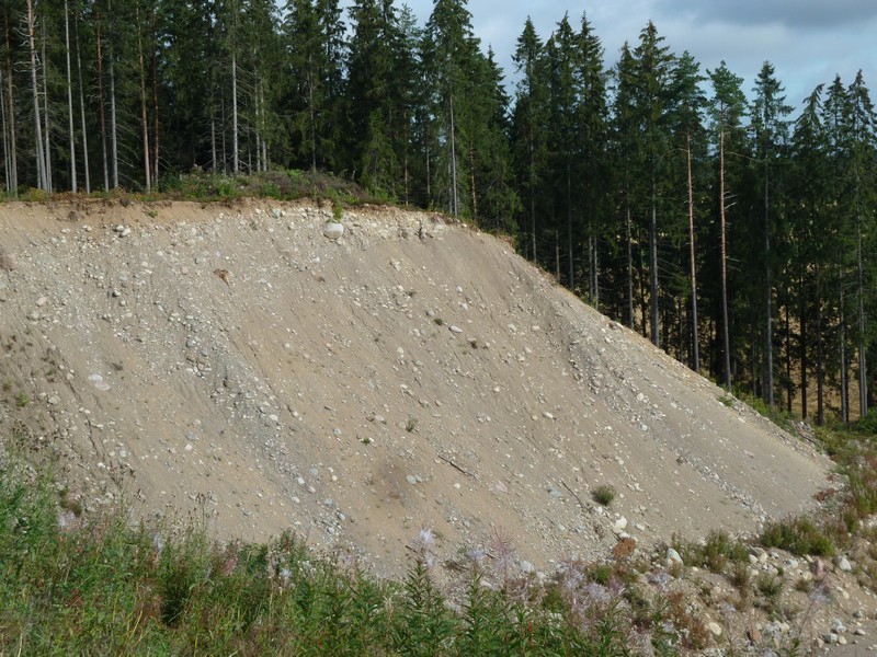
3.5 Eskers
As the glacial ice retreated towards its northwestern origin, strong streams of melting water formed rivers inside and on top of the ice sheet. These glacial streams carried various kinds of rock materials with them. These materials were then smoothed and layered by the force of the water. This till or moraine is what formed the Finnish eskers. It consists of alternating layers of sand and gravel.

When the edge of the continental glacier retreated towards the northwest, the esker deltas continued to form near its edge. This is how the eskers formed long, continuous series. Eskers are usually several kilometers long and tens of meters high. The largest eskers were formed when till accumulated between two sheets of ice.
The largest esker in Finland is also the largest gravel esker in the world. It is called Pyynikinharju, and it is located in Tampere, between the lakes of Pyhäjärvi and Näsijärvi. It is 82 meters tall..
Eskers are one of the most instantly recognizable features of Finnish landscapes. They are also important spots for groundwater collection and recreation. However, many eskers have been gradually destroyed by construction and gravel collection. Nowadays, eskers are protected by strict regulations concerning gravel collection and construction on their slopes.
 An esker in Jokioinen. This esker has been used as a source of sand and gravel.
Gallery: Eskers


3.6 The Salpausselkä ridges
 When the climate grew colder for small periods of time during the glacial melting stage, the ice sheet retreated at a slower rate and sometimes stopped moving completely. When this happened, loose materials accumulated near the edge of the ice sheet, forming steep ridges of terminal moraine. The Finnish Salpausselkä ridges are examples of such structures.
There are three Salpausselkä ridges, and they all comprise of till, gravel and sand, as well as various other unsorted materials carried by the glacial streams. Together, they are approximately 600 km long, and at times they are 60–80 meters higher than the surrounding environment.
The first and oldest Salpausselkä ridge was formed approximately 12 000 years ago and runs through Hanko, Lohja and Lappeenranta towards the northern side of Lake Ladoga. It stops the waters of the Finnish Lakeland from flowing into the Baltic Sea. The second Salpausselkä ridge is a little lower, located 20 kilometers to the north from the first one. It separates lakes Vesijärvi and Päijänne, and forms the southeastern shores of Pihlajavesi and Puruvesi. It was formed approximately 11 500 years ago.
The third and shortest Salpausselkä ridge was formed approximately 11 000 years ago. It stretches from Kemiönsaari to Hämeenlinna. The island of Jurmo in the Finnish Archipelago is also a continuation of this ridge.
The northern slopes of the Salpausselkä ridges are quite steep and consist of till and gravel that were mixed by the retreating glacial ice. The summits of the Salpausselkä ridges are relatively flat, wheras the southern slopes are gentle and consist of gravel and sand. The feet of the ridges consist of fine sand and clay. This soil type has been advantageous for the cultivation of crops, which is why agricultural activity has concentrated near the feet of the Salpausselkä ridges.