10. Earth's climate
Contents
10.2 Experiment: How does solar radiation divide accross the Earth's surface?
10.3 Earth's climate
10.4 Factors that influence climatic conditions
10.5 Earth's four geographic zones
Gallery: Earth's four geographic zones
10.6 Climate diagrams
10.7 Europe's climatic regions
Summary
10.1 Solar heat radiation
 Different areas on Earth experience drastically different climatic conditions. When Finland is in the midst of a freezing winter, South Africa experiences the heat of summer. This is the combined result of Earth's slanted axis and the planet's yearly movement on its orbit around the Sun.
During different times of the year, different parts of the Earth are slanted towards the Sun. In December and January, the Southern Hemisphere is tilted towards the Sun, whereas in June and July, the Northern Hemisphere is tilted towards the Sun.
When moving closer to the Earth's equator, the climate gradually becomes warmer and steadier. This is due to the fact that the heat radiation of the Sun is concentrated on a smaller surface area near the equator than it is near the polar regions of the planet. As a result, the Sun shines at its warmest on the regions near the equator. In contrast, the heat radiation is less effective near the planet's polar regions.
The year
10.2 Experiment: How does solar radiation divide across the Earth's surface?
 You can gain a more nuanced understanding of how solar radiation is divided on the Earth's surface by conducting a small experiment.
For this experiment, you will need a ball (a soccer ball, a balloon or a globe) and a lamp (a flashlight or a table light).
Set the ball on a table or hold it up with your hand. Shine the light directly at the ball. Focus the beam of light near the ball's middle part (its equator), and move it towards the bottom and top parts of the ball (its poles).
How does the spot of light change when moving the light from the center of the ball towards its top or bottom?
10.3 Earth's climate
The climate of a certain region is primarily influenced by the following three factors:
- its distance from the equator.
- its distance from seas or oceans.
- its elevation in relation to the sea level.
The color signifies the precipitation rate of an area: a red color suggests heavy rain, whereas a green color signifies a low amount of rainfall.
- The equator receives the largest amount of rainfall. (1:10–1:30).
- The regions with the least rainfall are located along the Tropic of Cancer and the Tropic of Capricorn: these areas include the Saharan desert, the Arabian peninsula, and some parts of Australia. (1:30–1:45).
- Strong, regional storms occur almost everywhere on the planet. (1:50–2:05).
- Air temperature has an effect on the amount of rainfall. In turn, temperature and rainfall determine the kind of vegetation a certain area has. If the climate changes, the amount of rainfall in different areas will change, causing a change in the vegetation of these areas. (2:10–).
- Stop the video at 2:36. You can see how Earth's temperature is divided into regions.
© NASA
10.4 Factors that influence climatic conditions
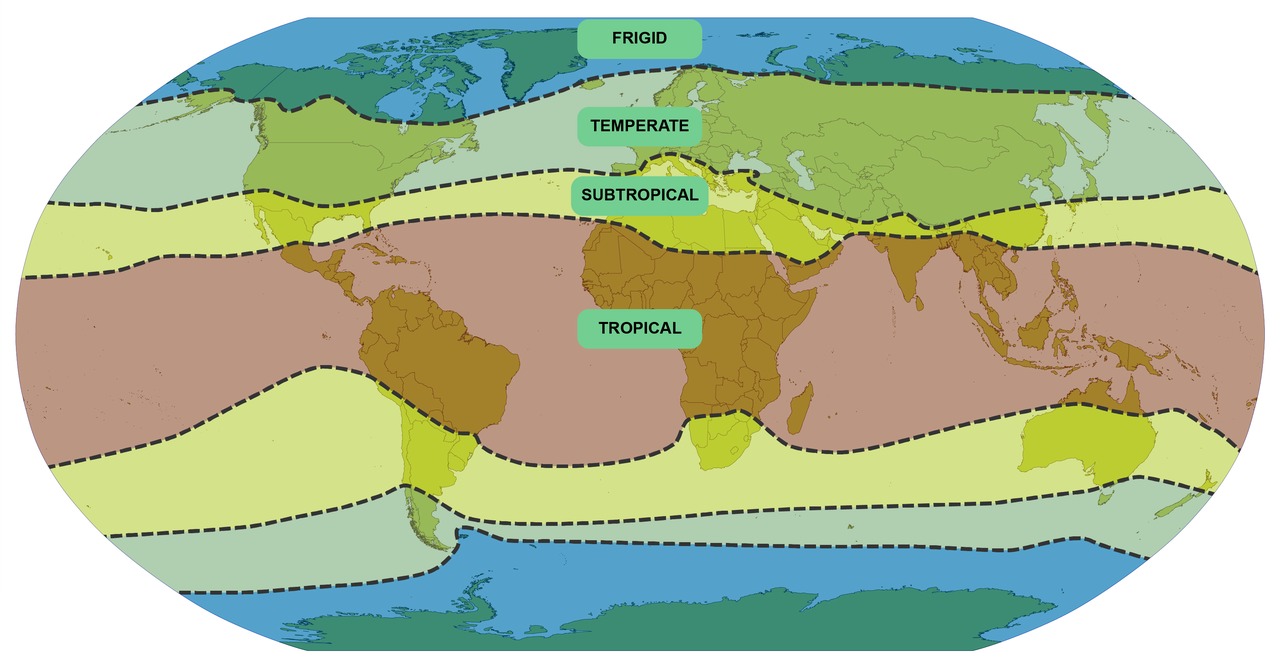
The regions closest to the North and South poles comprise the planet's frigid zones. When moving towards the equator from these areas, the temperate and subtropical zones are reached. The tropical or torrid zone is located near the equator.
The planet's geographical zones.
The borders of the planet's geographical zones do not follow the latitudes compeletely. This is caused by the fact that many regional factors influence the climates of different areas. Such factors include winds, ocean currents, distance from the sea and topography. Winds move air from one place to another and cause movement in surface waters. Closeness to the sea evens out temperature variation between summer and winter, as the water of the sea cools down at a slower rate than the surface of the planet.
Average temperatures of different cities in February. The warming effect of the sea and its currents are shown in the average temperatures of Vancouver and Glasgow.
Areas of high elevation, such as mountain ranges, can belong to a colder climatic regions than other areas of the same latitude.

When climbing a mountain, the air temperature decreases by approximately 0,6 degrees Celsius per each 100 meter increase in elevation. As a result, mountain peaks experience different climatic conditions than valleys do.

The map displays the variation in yearly average temperature on planet Earth. Notice that the changes in temperature are not only deterermined by latitude, but are actually the products of a multitude of factors.
10.5 Earth's four geographic zones
 The frigid zone
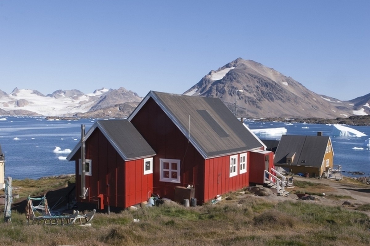
The frigid zone is a geographical zone that is found near the polar regions of planet Earth. The northernmost parts of North America and Europe are located in the frigid zone, as are Greenland, half of Iceland, and the whole continent of Antarctica. There are no areas belonging to the frigid zone in South America.
The frigid zone experiences an extremely cold winter every year. The northernmost parts of the region have no summer. Snow rarely has time to melt completely during the summer. The monthly average temperature never rises above 10 degrees Celsius.
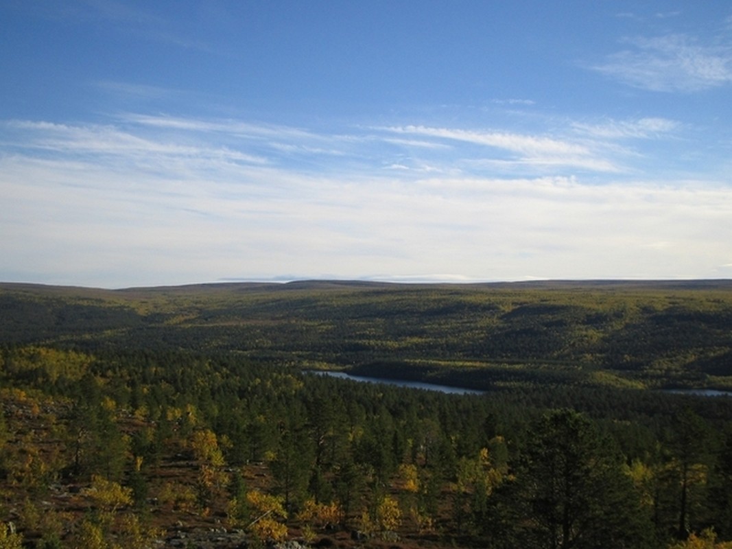
The temperate zone
 Most parts of North America and Europe are located in the temperate zone. The southernmost tip of South America also belongs to the temperate zone. The temperate zone experiences cold winters with occasional snowfall. Summers in the temperate zone are quite warm.
The temperate zone experiences four distinct seasons: spring, summer, autumn and winter.
In the temperate zone, the average temperature of the warmest month exceeds +10 degrees Celsius, whereas the average temperature of the coldest month can range between 0-18 degrees Celsius. This means that the winter temperatures of the temperate zone are quite varied. You can see this when comparing the winter temperatures of Rovaniemi, London, München and Moscow. The climatic variation within the European temperate zone is examined in further detail below.
 The subtropical zone
The subtropical zone is located near the tropics of Cancer and Capricorn. A good example of a subtropical climate zone is found in the Mediterranean region, which includes countries such as Greece, Italy, and Spain.
Only a small part of North America is located in the subtropical zone. This part runs through Florida to California. In South America, the subtropical zone encompasses an area between the Andes and the equator.
The subtropical zone has a short, temperate winter, which is balanced by a long and warm summer. The yearly average temperature is approximately 15 degrees.

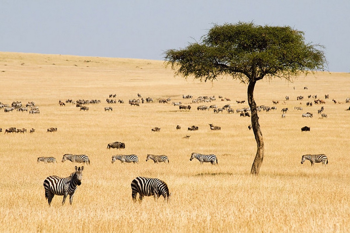
The tropical zone
The tropical zone is located near the equator. This geographical zone includes most of Central America and Southern America between the equator and the Tropic of Capricorn. There are no regions belonging to the tropical zone in Europe.
A large part of Africa is located in the tropical zone. The climate of the tropical zone is characterized by an endless summer. The sun shines throughout the year, and there is no variation between seasons.
Gallery: Earth's geographical zones


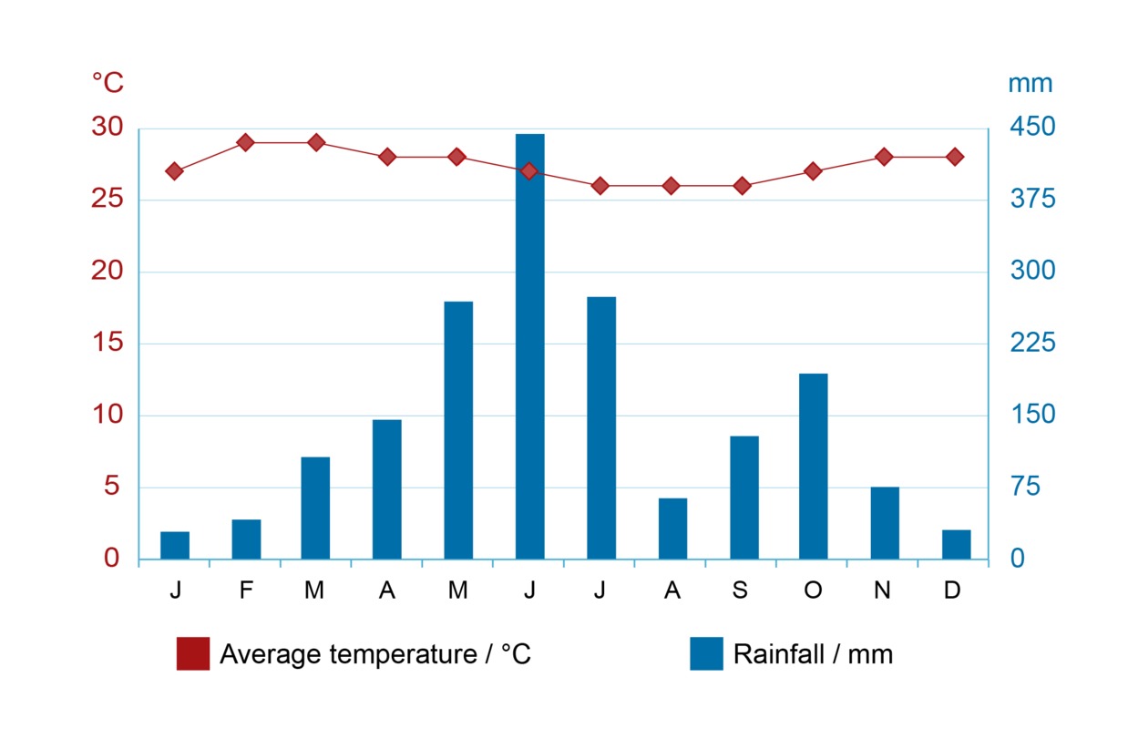
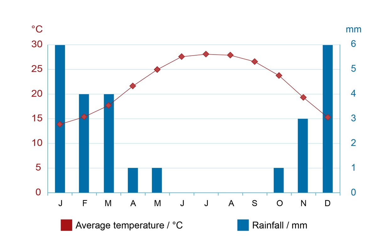
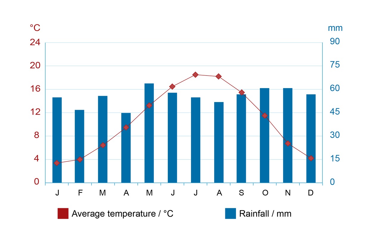
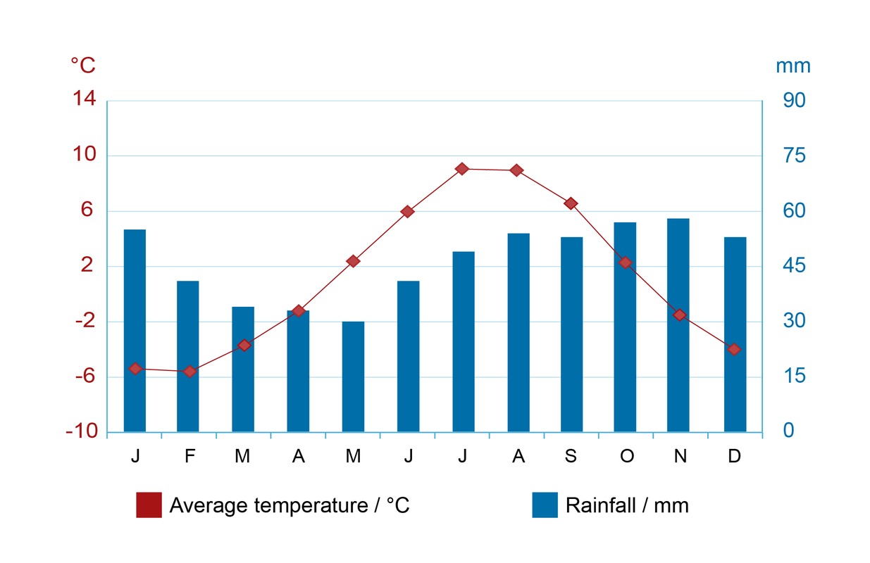
10.6 Climate diagrams
The left-hand side of the climate diagram shows the temperature scale either in Celsius or Fahrenheit. The right-hand side of the diagram displays the precipitation in millimeters.
A climate diagram provides an overall picture of the climatic conditions of a certain area.

How to interpret a climate diagram
Climate diagrams of geographical zones

10.7 Europe's climatic regions

Europe is a continent of three geographic zones: the frigid, temperate, and subtropical zones. The only geographic zone not to be found in Europe is the tropical zone, which only exists at latitudes closer to the equator.
1. The frigid zone
The frigid zone covers regions near the North and South poles. The northernmost parts of Europe, such as the northern tip of Scandinavia and the northern half of Iceland, are located in the frigid zone.
The monthly average temperature never rises above 10 degrees Celsius. Similar climatic conditions can be found in regions of high elevation.
2. The temperate zone

Most of Europe is part of the Northern temperate zone. This zone is mostly located between the Arctic Circle and the latitude of 40°N, covering the area between Scandinavia and Northern Italy.
Because the climatic conditions of the temperate zone vary greatly depending on various factors, it is divided into three climatic regions: maritime climate, continental climate and intermediate climate.
2a. Maritime climate
The westernmost parts of the European are located near the shores of the Atlantic Ocean. These regions receive winds from the ocean, resulting in high amounts of rainfall. These areas comprise the European maritime climate region.
Great Britain (the diagram on the right), Portugal, and Northern France are all part of the maritime climate region.
 The maritime climate is characterized by high amounts of rainfall throughout the year and a slight variation in temperature between the summer and the winter. The smallness of these temperature variations are caused by vicinity to the sea. During the summer, ocean winds bring cold air to the continent. During the winter, the winds bring warm air that helps to keep the winter temperatures relatively temperate.
2b. Continental climate
Most areas of Central and Eastern Europe comprise of inland regions that experience a continental climate. Russia, for example, is located almost completely within the continental climate region.
The continental climate is the opposite of the maritime climate in a number of ways.
Continental climate regions experience significant temperature variation throughout the year. The summers are hot and the winters are cold.
 Continental climate regions receive less rainfall than maritime climate regions, as winds blowing from the ocean do not carry as much rainfall to the central parts of the continent. The rainfall is concentrated to the summer months, whereas the winter is relatively dry.
2c. Intermediate climate
The intermediate climate region is located between the maritime and continental climate regions, and shares characteristics with both.
Most of Scandinavia and Central Europe is located within this climatic region.
This climatic region experiences four clearly divided seasons. Summers are more temperate than those in the continental climate region, whereas the winters are colder than those in the maritime climate region.
3. The subtropical zone
The subtropical zone is located between the temperate and tropical zones. In Europe, it comprises the areas below the latitude of 40°N. The European subtropical zone is located near the Mediterranean. It covers countries such as Spain, Italy and Greece.
The summer is long and hot, whereas the winter is short and temperate. The yearly rainfall is concentrated around the winter months. The yearly average temperature is approximately 15 degrees Celsius.
Summary
- The Earth has four geographic zones: the frigid, temperate, subtropical and tropical zones.
- The European temperate zone consists of three climatic regions: the maritime, continental, and intermediate climatic regions.
- Winds, ocean currents, elevation and topography all have an effect on the climatic conditions of an area.
- A climate diagram displays the average monthly temperature in Celsius and the total monthly rainfall in millimeters.