9. Weather
Contents
9.1 Meteorology
 The word meteorology was first mentioned in the book Meteorologica by the Greek philosopher Aristotle around 340 BCE. The book tried to answer the questions of where different weather phenomena came from and how they could be predicted. The scientific field of meteorology emerged in the 17th century, after various inventions that could be used to measure weather conditions, such as thermometers, barometers and anemometers, were developed.
Although nowadays most meteorological measurements and predictions are made by weather satellites and computers, observations are still important when making predictions about the future weather. Short-term predictions about the weather can be made by observing the current weather conditions. These observations are made from weather stations as well as with weather radars.
After a prediction about the weather has been made, a meteorologist will evaluate the prediction and decide whether or not it is reliable. By entering new observations and data to their specialized meteorological software, the meteorologist can develop the prediction and make it more accurate as time passes and the weather conditions change.
Typically, the shorter the time span a prediction covers, the more reliable the prediction will be. This is why meteorological predictions are made for 5 days at the most. On longer time spans, the predictions will quickly become unreliable.
Weather predictions:
9.2 High and low pressure zones
Air pressure is one of the key observations that help meteorologists to make predictions about the weather. High and low air pressure are terms that describe the weight or pressure of the atmosphere per a unit of surface area. When evaluating the weather, changes in air pressure are more important than the exact values of air pressure measurements.

Usually, as a low pressure zone advances near our region, the weather will "get worse", meaning increased cloud cover and rainfall.
Conversely, when a high pressure zone begins to form near our region, the weather will "get better", meaning clear skies and sunshine.
Low pressure zones are formed when the surface of the Earth warms up. This causes the air mass directly above the planet's surface to grow warmer as well. Because warm air always rises above cold air, the warm air mass will begin to flow upwards. This air mass will move to high altitudes, lose its warmth, and begin to sink back towards the lower areas of the atmosphere. When an area accumulates new air mass due to this process, it will form a high pressure zone.
Wind is created by air moving from high pressure zones (where there is a lot of air) towards low pressure zones (where there is less air). The more significant the difference between the air pressures of high and low pressure zones is, the stronger the resulting wind will become. In the Northern Hemisphere, winds cycle around the center of the low pressure zone in a counterclockwise direction, whereas in the Southern Hemisphere they cycle the center in a clockwise direction. The direction of these winds is indicated by arrows on the weather map.

A day of high air pressure in Finland.
During the summer, the low pressure zones are often weaker than they are in winter, and they can bring long periods of rain with them. During the winter, low air pressure usually results in a grey and temperate weather suitable for outdoor activites.
High air pressure causes clear, sunny and warm weather during the summer. However, the coldest weather conditions during the year are also experienced during periods of high pressure. During the winter, high air pressure causes clear skies, which make warmth escape into space from the planet's atmosphere.
 Earth's winds right now!

Usually, as a low pressure zone advances near our region, the weather will "get worse", meaning increased cloud cover and rainfall.
Conversely, when a high pressure zone begins to form near our region, the weather will "get better", meaning clear skies and sunshine.
Low pressure zones are formed when the surface of the Earth warms up. This causes the air mass directly above the planet's surface to grow warmer as well. Because warm air always rises above cold air, the warm air mass will begin to flow upwards. This air mass will move to high altitudes, lose its warmth, and begin to sink back towards the lower areas of the atmosphere. When an area accumulates new air mass due to this process, it will form a high pressure zone.
Wind is created by air moving from high pressure zones (where there is a lot of air) towards low pressure zones (where there is less air). The more significant the difference between the air pressures of high and low pressure zones is, the stronger the resulting wind will become. In the Northern Hemisphere, winds cycle around the center of the low pressure zone in a counterclockwise direction, whereas in the Southern Hemisphere they cycle the center in a clockwise direction. The direction of these winds is indicated by arrows on the weather map.

A day of high air pressure in Finland.
During the summer, the low pressure zones are often weaker than they are in winter, and they can bring long periods of rain with them. During the winter, low air pressure usually results in a grey and temperate weather suitable for outdoor activites.
High air pressure causes clear, sunny and warm weather during the summer. However, the coldest weather conditions during the year are also experienced during periods of high pressure. During the winter, high air pressure causes clear skies, which make warmth escape into space from the planet's atmosphere.
9.3 Cyclones and the polar front
Near the planet's equator, where the amount of solar radiation is the highest, the air grows warmer continuously. This creates an area of constant low pressure. When this air rises it cools down and begins moving towards the south and the north.
In the planet's polar regions, the air cools down and forms areas of high pressure. Because differences in the atmosphere's air pressure always try to even themselves out, the air begins to flow away from the polar regions.
The warm and cold air currents meet each other near the 60th latitudes. The cold air mass will push beneath the warm air mass, creating an area of low air pressure. This results in the formation of the polar front.
When warm air is pushed below the cold air mass, the polar front grows bends that develop into large cliffs. These bends and cliffs are the sources of moving low pressure centers or cyclones. The polar front usually develops various low pressure centers, which move from the Atlantic towards different directions. In the weather map, these cyclones are marked with a "shark fin" symbol.
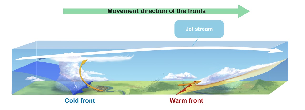
When these "shark fins" pass over a region, they change the weather conditions drastically. Cyclones bring warm and humid air to Finland from the Atlantic. This warm and humid air often spoils summer vacations and causes problems for the autumn harvest. The moving low pressure zone contains two fronts: the first front (or the Eastern front) is warm, whereas the second front (or the Western front) is cold.
 As the warm front closes in, the winds will grow stronger and large clouds will form in the horizon. These vast clouds result in a large zone of steady rain that can continue for a long time. After the warm front passes, the winds slow down and the sky will grow clear once again.
When the second, cold front closes in, the wind will once again grow stronger. Smaller clouds will form in the horizon. If these clouds produce rain, it will often be heavy, short and regional. After the cold front passes, the sky grows clear once again.
After the cold front has passed, the cycle will begin again with a new cyclone. The arrival of cyclones is easy to predict, as they generally move at a speed of approximately 50 kilometers per hour.
When cyclones do not pass through a region, the result is clear and sunny high pressure weather.

Cyclone. The first front consists of warm air and is followed by a second front consisting of cold air.
In the planet's polar regions, the air cools down and forms areas of high pressure. Because differences in the atmosphere's air pressure always try to even themselves out, the air begins to flow away from the polar regions.
The warm and cold air currents meet each other near the 60th latitudes. The cold air mass will push beneath the warm air mass, creating an area of low air pressure. This results in the formation of the polar front.
When warm air is pushed below the cold air mass, the polar front grows bends that develop into large cliffs. These bends and cliffs are the sources of moving low pressure centers or cyclones. The polar front usually develops various low pressure centers, which move from the Atlantic towards different directions. In the weather map, these cyclones are marked with a "shark fin" symbol.
When these "shark fins" pass over a region, they change the weather conditions drastically. Cyclones bring warm and humid air to Finland from the Atlantic. This warm and humid air often spoils summer vacations and causes problems for the autumn harvest. The moving low pressure zone contains two fronts: the first front (or the Eastern front) is warm, whereas the second front (or the Western front) is cold.
 As the warm front closes in, the winds will grow stronger and large clouds will form in the horizon. These vast clouds result in a large zone of steady rain that can continue for a long time. After the warm front passes, the winds slow down and the sky will grow clear once again.
 When the second, cold front closes in, the wind will once again grow stronger. Smaller clouds will form in the horizon. If these clouds produce rain, it will often be heavy, short and regional. After the cold front passes, the sky grows clear once again.
After the cold front has passed, the cycle will begin again with a new cyclone. The arrival of cyclones is easy to predict, as they generally move at a speed of approximately 50 kilometers per hour.
When cyclones do not pass through a region, the result is clear and sunny high pressure weather.

Cyclone. The first front consists of warm air and is followed by a second front consisting of cold air.